
Pemetaan Kejadian Kasus Demam Berdarah Dengue di Kabupaten Kediri Tahun 2023
DOI:
https://doi.org/10.5281/zenodo.14561193Keywords:
Dengue Fever, Geographic Information System , Spatial Distribution , Public Health PreventionAbstract
Background: The cases of dengue fever (DBD) in Indonesia show a fluctuating trend. DBD remains a public health issue because it affects all age groups and can lead to death. Efforts to control and prevent DBD are crucial to reduce its impact on the community. The purpose of this study is to illustrate the distribution pattern of DBD cases in Kediri Regency in the form of a map. Methods: This study uses a descriptive observational quantitative research design. The research analyzes secondary data obtained from the Kediri Regency Health Office using Geographic Information System (GIS). Data was collected from routine health reports and mapped to identify spatial patterns of DBD cases across the subdistricts. Results: The subdistrict with the highest DBD cases is Pare with the highest number of cases, totaling 106,968 cases, followed by Mojo subdistrict with 87,280 cases. The subdistrict with the lowest cases is Kunjang, with 32,641 DBD cases. The distribution pattern of these cases indicates areas with higher population density and environmental factors may contribute to the increased incidence in certain subdistricts. Conclusions: Optimal handling and prevention of DBD cases should be implemented to prevent an increase in DBD cases. Additionally, targeted interventions in high-risk subdistricts, such as Pare and Mojo, are essential to reduce the overall incidence of DBD.
Downloads
References
Basri, Achamad, A., Hazriani, & Munthakhabah, C. (2023). Sistem Informasi Geografis Pemetaan dan Prediksi Pertumbuhan Penduduk Menggunakan Regresi Linear. Bulletin of Information Technology, 4(2), 171–177.
Bisyri, A. A. (2021). Sistem Informasi Geografis " Penggunaan Gis Dalam Dunia Kesehatan " Kesehatan ” Kelas A Oleh : Achmad Alfiyyan Bisyri. December.
Dompas, B. E., Sumampouw, O. J., Umboh, J. M. L., 2020, W., & 2021, W. (2020). Apakah Faktor Lingkungan Fisik Rumah Berhubungan dengan Kejadian Demam Berdarah Dengue. Journal of Public Health and Community Medicine, 1(2), 11–15.
Hafsari, D. M. (2024). Trends Analysis of Dengue Hemorrhagic Fever in Campurejo East Java, Indonesia 2019-2021. Ficco Public Health Journal, 1(01), 13-20.
Hasana Isnaeni. (2022). Pengaruh Promosi Kesehatan Pada Kejadian Penyakit Demam bberdarah Dengue (DBD) Terhadap Perubahan Perilaku Masyarakat. Pelita Sains Kesehatan, 2 (1), 8–13.
LabGeospasial. (n.d.). Bagaimana Data Spasial Dapat Membantu dalam Pengambilan Keputusan? https://labgeospasial.com/bagaimana-data-spasial-dapat-membantu-dalam-pengambilan-keputusan/
Lindawati, N. Y., Murtisiwi, L., Rahmania, T. A., Damayanti, P. N., & Widyasari, F. M. (2021). Upaya Peningkatan Pengetahuan Masyarakat Dalam Rangka Pencegahan Dan Penanggulangan Dbd Di Desa Dlingo, Mojosongo, Boyolali. SELAPARANG Jurnal Pengabdian Masyarakat Berkemajuan, 4(2), 473. https://doi.org/10.31764/jpmb.v4i2.4305
Sabiq, R. M., & Nurwati, N. (2021). Pengaruh Kepadatan Penduduk Terhadap Tindakan Kriminal. Jurnal Kolaborasi Resolusi Konflik, 3(2), 161. https://doi.org/10.24198/jkrk.v3i2.35149
Sihombing, L. A., & Utami, C. F. (2023). Hirarki Dan Distribusi Kota: Penyebaran, Dan Kepadatan Penduduk Serta Implikasinya Terhadap Infrastruktur. Jurnal Ilmiah Sosial Teknik, 5(2), 218–229.
Wilson, R. (2023). Sistem Informasi Geografis Pemetaan Wilayah Penyebaran Demam Berdarah Dan Lokasi Rumah Sakit Terdekat Di Kota Bandar, Jurnal Teknologi Pintar, 3(4).
More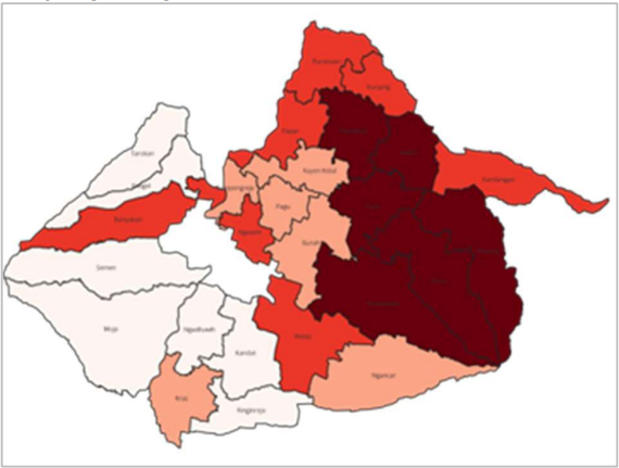
Downloads
Published
Issue
Section
License
Copyright (c) 2024 Dwi Regina Istiqlala (Author)

This work is licensed under a Creative Commons Attribution 4.0 International License.