
Pemetaan Hasil Kredensial Tenaga Kesehatan Berbasis Sistem Informasi Geografis di Kabupaten Kediri
DOI:
https://doi.org/10.5281/zenodo.14561221Keywords:
Credentialing, Geographic Information System, Doctor Distribution, KediriAbstract
Background: The presence of doctors who have and have not completed their credentialing should be accompanied by easy access to information. The rapid development in the field of technology and information provides convenience in accessing information through visualization media. The purpose of this study is to map the distribution of healthcare professionals, specifically doctors who have completed their healthcare credentialing in Kediri Regency. Methods: This study uses an observational research design, analyzing secondary data obtained from the Kediri Regency Health Office, using Quantum GIS software. Data was collected from health reports and mapped to visualize the distribution of doctors who have completed their credentialing across the health centers. Results: Kediri Regency has 37 health centers (puskesmas), of which 10 health centers implemented credentialing in 2022, and 27 others implemented credentialing in 2023. The map created provides a clear visualization of the distribution and status of credentialing across the region, helping to identify areas that may require further attention or intervention. Conclusions: Information about healthcare professionals who have completed their credentialing, which can be accessed quickly, can be presented through information technology implemented in a Geographic Information System.
Downloads
References
Kementrian Kesehatan RI. (2021) Petunjuk teknis kredensial tenaga kesehatan di pusat kesehatan masyarakat – jakarta
Peraturan Pemerintah Nomor 32 Tahun 1996 Tentang Tenaga Kesehatan.
Achmad, N., Widyasari, T., & Syaifullah, M. (2021). Analisis Hujan Wilayah dengan Metode Poligon Thiessen dan Isohiet di Kabupaten Bantul Menggunakan Software Qgis dan Ms Access. Rancang Bangun Teknik Sipil.
Budiyanto, E. (2014). Sistem Informasi Geografis dengan Quantum GIS.
Satrianegara, M. Fais. (2014). Organisasi dan Manajemen Pelayanan Kesehatan. Jakarta: Salemba Medika.
Riyanto, dkk. (2009). Pengembangan Aplikasi Sistem Informasi Geografis Berbasis. Dekstop dan Web. Yogyakarta : GAVA MEDIA.
More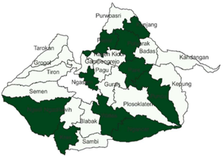
Downloads
Published
Issue
Section
License
Copyright (c) 2024 Ananda Azmi Mufida (Author)

This work is licensed under a Creative Commons Attribution 4.0 International License.